Doppler Current Meter JLN-652
Features
The new JLN-652 Doppler current meter integrates acompelling combination of function and features, packedinto a compact space-saving design, enabling quick andaccurate acquisition of speed and tidal current data.
3D twist mode
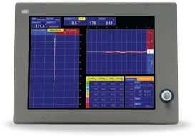
You can view the current direction and speed in real time with the twist mode. With this advanced feature, an operator is able to assess current speed and direction, enhancing the timing on when to deploy the nets in the water. Naturally, the twist display mode is accompanied with a wide range of information, such as current speed range, depth range, temperature history from external sensor and more.
Up and down current
JRC engineers listened closely to feedback given by captains and realized yet another unique function in this class of current meters. The JLN-652 is able to accurately measure up and down current, particularly useful to predict the sinking ratio of your nets by following the natural motion of the underwater current.
50 independent measuring layers at deep current
The JLN-652 Doppler current meter has the ability to process and display continuous tidal currents of 50 independent measuring layers down to maximum 200 meter depending on sea condition. To simplify matters, the user only has to set five depths layers (A, B, C, D, E), of which each layer is measured in four directions. The 50 layers are automatically set relative to depth which has been indicated. The user can select the depth of each layer, showing different information. You can also select bearing*1 displayed as North-up (with true north at the top of the display) and Head-up (with bow at the top of the display).
Automatic speed relative to bottom
Normally run automatically, the new JLN-652 allows bottom tracking with depths up to approximately 250*2 meters, measuring direction and speed relative to the sea bottom. If sea bottom becomes too deep, it automatically switches to water tracking mode or through GPS mode, depending on user selection.
Bottom current tracking
The bottom current layer (E) has the ability to automatically shift and display the current close to bottom following the contours of the sea bottom. This is of great help for the operator when fishing in areas with frequently variable depth.
*1 : Heading input necessary
*2 : Actual depth value depend on sea and bottom condition
Operation
Dedicated keyboard
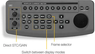
The new JLN-652 allows you to carry out all operations simply by using the keyboard. The layout has a full complement of keys, including direct STC and GAIN, to adjust noise under surface of the water level and receiver sensitivity respectively. The keyboard also has one-touch menu keys to access different display modes instantly as well as a special frame-selector to navigate quickly through a variety of menu items on display.
Fish finding
You can view fish echoes in four-directions, two-directions ahead, or in any one direction, allowing for easy fish tracking. Just as any typical fish finder, you can set the display to present fish echo and seabed condition simply by adjusting the sensitivity.
Alarms
There is a wide range of alarms available on the JLN-652. With all alarms, for example, when depth becomes shallower than the parameter set, a warning message pops up, allowing the operator to take action, contributing to safer navigation and more efficient fish finding.
High resolution display
The Doppler current meter not only measures data with unmatched accuracy but also features a high resolution output of 1024 by 768 pixels (XGA) which provides excellent and efficient tidal analysis.
Black box configured
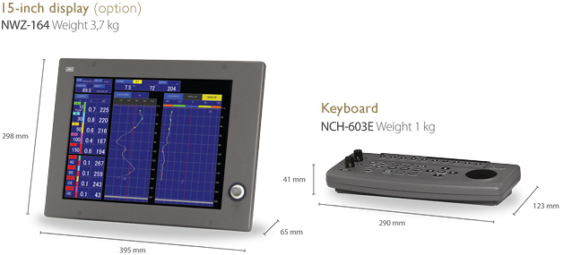
The JLN-652 consists of a display (option), processor and keyboard, allowing for a flexible installation approach in confined spaces. For those who prefer to specify their own display, the JLN-652 allows you to choose what type and size of display to connect to the unit, as long as it supports XGA.
System
Display modes
This Doppler current meter has 16 comprehensive and easily readable display modes for efficient tidal analysis. With our dedicated keyboard you can navigate through all common used tasks effortlessly.
Upgrade path
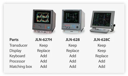
Our standard scope of supply has been set as a minimum configuration. This allows ease of upgrading from previous models (see left). In the case of a new installation, simply select the transducer and installation accessories from the option list.
Easy interfacing
The new Doppler current meter integrates two-way interfacing, allowing you to easily connect a wide range of additional (NMEA) navigation equipment. Up to 1000 memory points of current and track data can be saved on USB memory. (USB not included).
In the box
- Processor
- Keyboard
- Manuals
- Spare parts
Options
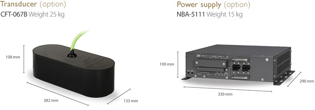
| Transducer element (25m cable attached) | CFT-067B |
|---|---|
| Stuffing tube (iron hull/FRP hull) | MPJD30076/MPJD30078 |
| Transducer with stuffing tube | NKF-779 |
| Transducer with stuffing tube + iron tank | NKF-780 |
| Matching box | NQD-2422 |
| 15-inch display | NWZ-164 |
| Bracket 15-inch display | MPBX42944 |
| Sun shade 15-inch display | MPOL30369 |
| 10-inch display | NWZ-211 |
| Keyboard ext. cable (10m) | CFQ-6999 |
| Power supply | NBA-5111 |
Specs
| Model | JLN-652 |
|---|---|
| Measuring method | 2-axis four beam pulse Doppler |
| Frequency | 240 kHz |
| Resoluton | 1024 by 768 pixels (XGA) |
| Power supply | 21.6 to 31.2V DC (100 to 230V AC option), Power consumption: <270VA |
| Ambient conditions | Temperature: -15 to 55°C, Relative humidity: 0% to 93% non-condensing |
| Current measurement | |
| Current speed range | 0 to 10 kn (accuracy ± 2% rms or 0.2 kn, whichever is greatest) |
| Current direction display | All surroundings 360° and numerical values with 32 bearing points |
| Current layers | Maximum: 50 layers (numerical data readout from 5 pre-selected layers) |
| Current depth | 2 to 30 m (in shallow sea mode), 12 to 100 m (in standard mode), Maximum: up to 200¹ m |
| Bottom measurement | Minimum depth: 5 m, Maximum depth: 350¹ m |
| Depth setting | 2 to 500 m |
| Current reference | Doppler or GPS |
| Ship speed measurement | |
| Fore/aft range | -10 to 40 kn (accuracy ± 1% rms or 0.1 kn, whichever is greatest) |
| Port/starboard range | -10 to 10 kn (accuracy ± 1% rms or 0.1 kn, whichever is greatest) |
| Measurement speed | Ground speed: 5 to 250 m, Maximum: up to 350¹ m, Water speed: more than 10 m (both display simultaneously) |
| Distance run | 0 to 99,999.99 NM (accuracy ± 1% rms or 0.1 kn, whichever is greatest) |
| Auto shift bottom tracking | Yes |
| Main performance | |
| Function | Measuring current, ship speed, depth, fish finder, track plotting, graph display, profile display, self test, alarm function |
| Display modes | Current, ship, plot, graph, fish, profile |
| Alarms | Current speed, ship speed, depth, trip, timer, water temp, wind speed |
| Interfacing | |
| NMEA input (v1.5 to 3.01) |
Bearing: HDT, VHW, HDM, HDG, THS; Speed; RMC, VTG; Lat/Lon: RMC, GGA, GLL; Temperature: MTW; Wind: MWD, MWV |
| NMEA output (v1.5 to 3.01) |
VDVBW, VDVLW, VDVHW, VDDBT, VDDPT, VDCUR, PJRCL (ship speed and tidal current) |
| External trigger input | Receiver blocking by external transmission trigger |
| Distance output | 4x log pulse (200 pulse/NM) |
| JRC output | JRC format (for current data output) |
| Memory data output | USB/CF card (up to 1000 memory waypoints of current and track data can be saved) |
1. Actual depth values depend on sea and bottom conditions
